
Phipps Arch is a large, beefy arch located within Grand Staircase-Escalante National Monument in southwestern Utah. It’s beside Phipps Wash, a tributary of the Escalante River, and roughly between the towns of Escalante and Boulder.
Contents
A hike to Phipps Arch gave us our second destination arch of our spring 2013 Utah trip, after Colonnade Arch. And as you can tell from the photo, this is one beefy arch.

Essential Facts
- Route: Phipps Arch via Escalante River
- Activity: Day hike
- Distance: Oops.
- Elevation: Oops.
- Difficulty: fairly easy canyon walking, route finding can be a challenge for one turn, one section of a little climb
- Time: a little less that 6 hours for us, leisurely pace including lunch
Why Go
The arch is HUUUUGE. We’ve seen a lot of arches and if you put them all together they’d still be smaller than this big guy.
How to Go
There looks to be at least three trailheads from which you can reach Phipps Arch:
- the UT 12 crossing of the Escalante river (Escalante River route)
- off of UT 12 between the overlook and the Escalante river (Slickrock route)
- off of Old Sheffield Rd near Little Spencer Flat (down Phipps Wash route)
As we had three days of backpacking in front of us in the Grand Gulch, we opted for #1 as it’s the shortest. But it is also the wettest route — the trail requires fording/wading the Escalante three times. When we hiked it was 12″-18″ deep.
When to Go
For the Escalante River route, you could do it year-round. The water can be cold, and colder in the winter, so be prepared. In the summer, this is shady in the river & wash bottoms. But as always in canyon country, keep a sharp watch for those afternoon thunderstorms. Phipps Wash could definitely flash flood.
The other routes would be hot in the summer, so start early & be prepared for little shade.
Map & Route
Getting Started
- Trailhead: Escalante River Trailhead off of Rt 12 (view in Google Maps)
- Parking: maybe a dozen cars
- Bathroom: no
- Fees: none
Details
You’ll get your feet wet on this trail — it requires fording/wading the Escalante three times. When we hiked it was 12″-18″ deep.
Otherwise it’s not a particularly demanding trail. It runs even with the river and Phipps Wash, only becoming more difficult when the trail heads up to the arch. You’ll have to have decent map reading skills because you can’t see the arch from down in the wash. And finding the trail up can be tricky. Even after you’ve found the correct side canyon, the trail starts up immediately where the side canyon hits Phipps Wash — go up the side canyon much at all and you’ve gone too far. The only difficult spot on the trail up is one place where you’ll pull yourself up on a ledge.
Trip Report & Photos
30 April 2013
It’s always nice to have some water in canyon country hikes. Don’t get me wrong, I love the desert sparseness of slickrock — but the greenery can be a welcome addition. The shade in first section of this hike, along & in the Escalante, gave us a chilly start. But it’s a nice & clear trail that goes nearby some private land. After a few fords we made the big right turn to go up Phipps Wash.

Trail by the Escalante River

Escalante River

H fording the Escalante
The first part of the wash continues the shade for a while. But eventually the trees become scrub and the trail lifts you onto the canyon sides. As you can’t see the arch from the bottom, we totally missed the turn for the proper trail up to the arch — so we bushwhacked for a bit then found it. Above the wash it’s the usual Utah slickrock with plenty of cairns to mark where your way. Thee’s only one move that might be dicey: a high ledge that might require more effort from the less tall. But after that the arch soon shows itself.

Phipps Wash

Trickiest part of the trail

Phipps Wash Canyon
Phipps Arch itself makes the effort worthwhile. This might be the antithesis of Delicate Arch — an arch whose adjectives include “chunky,” “girthy,” “massive,” and “beefy.” And there’s some exploring you can do on either side of the arch to give you different vantage points.

Phipps Arch

Phipps Arch

Phipps Arch

Phipps Arch and nearby formations

Phipps Arch base
Although it’s not nearly as impressive as the arch, since you’re in the neighborhood you might want to drop by Maverick Natural Bridge. Just head back down the wash and it’s the next large side canyon to the west. It was a good place for a lunch break. Just a note, the USGS topo map for this area misplaces Maverick Natural Bridge to the north.

Maverick Natural Bridge

Maverick Natural Bridge
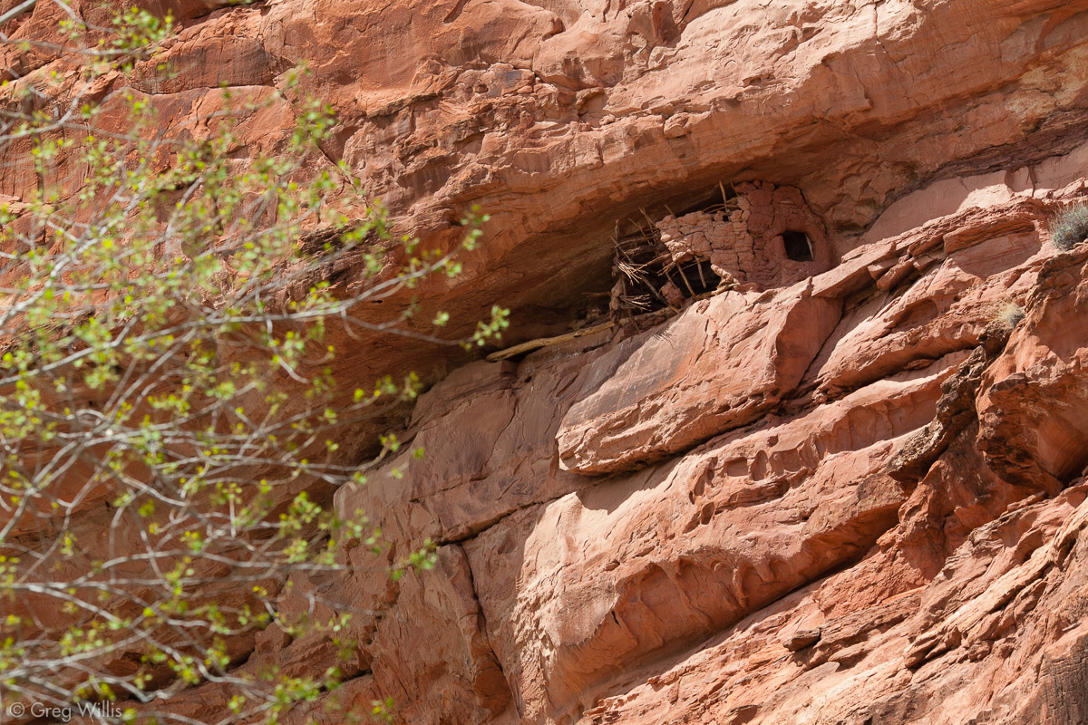
And on the way back to the trailhead, we spotted an ancestral Puebloan ruin high up on the Escalante canyon. Almost as if to give us a preview of of our next adventure on this trip — Hiking Upper Grand Gulch, Utah.
We’ve been visiting the Escalante/Boulder area for a number of years, yet this was the first time hiking to Phipps Arch. We’d have hike this years ago if I knew about it. I highly recommend making the effort.


Leave a Reply